Traffic census of state-controlled roads, Queensland
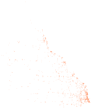
liveOne row per count site, traffic year and travel direction on the Queensland state-declared road network, from the Department of Transport and Main Roads traffic census. Each row has the annual average daily traffic (AADT), AADT and percentage for each Austroads vehicle class grouping, growth over one, five and ten years, the road section, the segment the site represents, the posted speed limit, the site's coordinates and the TMR district, region and council area. The publisher's workbook covers the latest eleven traffic years.
Also called: Traffic census for the Queensland state-declared road network, Queensland annual average daily traffic, TMR AADT data, Queensland heavy vehicle counts by road.
Part of Traffic volumes on Queensland state-controlled roads, 2 tables the publisher releases together: Traffic by hour of day and day of week, Queensland, 2025.
- What is in each row?
- One traffic count site, year and direction of travel, with the estimated annual average daily traffic, the daily traffic and share in each vehicle class, and growth over one, five and ten years. Each row also gives the road, the segment of road the site represents, the speed limit, the coordinates and the TMR district, TMR region and council area.
- Why do three rows share one site and year?
- Each site has a row for traffic with the gazetted direction of the road, a row against it and a row for both directions combined. Add only the rows for one direction, or use the BOTH DIRECTIONS row.
- Is every figure counted in the year it is for?
- No. A coverage site is not counted every year, and the publisher then estimates the year's traffic from an earlier count. The year counted column gives when the count was made.
Made for agents
Connect your AI agent
Any agent that connects to publicdata.au/mcp can find this dataset, read its 64 fields, count and filter across all 74,823 rows and diff its versions. Every answer names the version and carries Transport and Main Roads's attribution. No key.
Then ask it: What does Traffic census of state-controlled roads, Queensland hold, and what changed in the newest version?
claude mcp add --transport http publicdata https://publicdata.au/mcpOne command. No key, no account, no sign-up.
Settings, then Connectors, then Add custom connector, and paste https://publicdata.au/mcp.
On the web and in the desktop app.
https://publicdata.au/mcpStreamable HTTP. Cursor, VS Code or any client that connects to a remote MCP server.
Using https://publicdata.au/llms.txt, how many people died on Queensland roads in 2025, by month?For an assistant that reads the web and has no connector.
The dashboard above, live. Click to filter, add panels, share a link or embed a frame.
Query APIFilter and count from a URLaggregate?group=road_name&metric=max.aadt&traffic_year=eq.2025&travel_direction=eq.BOTH%20DIRECTIONS
Highest average daily traffic at one site by road where traffic year is 2025 and direction is BOTH DIRECTIONS: 179,550 GYMPIE ARTERIAL ROAD, 179,549 PACIFIC HIGHWAY (PACIFIC MOTORWAY), 168,230 BRUCE HIGHWAY (BRISBANE - GYMPIE), 167,788 SOUTH-EAST ARTERIAL ROAD (PACIFIC MOTORWAY).
Download it as Excel, CSV, JSON and 9 more formats
Pick a format and a version. Excel is picked first because it opens in the tools most offices have. The URL is yours to keep. A dated version never changes.
In your own tools
Use it in Excel, R, Python and more
Excel and Power BI read the CSV from its address and refresh from it. The R and Python packages take any dataset on this site by its slug, so a new dataset needs no new release. The DuckDB file attaches read-only over HTTPS, and a query reads only the blocks it touches.
The dated URL in the code never changes. https://publicdata.au/d/qld-traffic-census/latest/ redirects to the newest version.
https://publicdata.au/d/qld-traffic-census/latest/data.csvIn Excel choose Data, then From Web, and paste this address. Excel keeps it, so Refresh All reads the newest version. A sheet holds about a million rows; past that, load the query to the Data Model.
https://publicdata.au/d/qld-traffic-census/latest/data.csvIn Power BI Desktop choose Get data, then Web, paste this address and choose Anonymous when asked how to sign in. A scheduled refresh reads the same address, so the report follows each new version.
library(publicdataau)
df <- pd_read("qld-traffic-census")
pd_attribution(df)install.packages("publicdataau"). pd_read() fetches the version's Parquet file; pd_rows() and pd_aggregate() ask the query API instead, and pd_connect() attaches the DuckDB file.
import publicdata_au as pd_au
df = pd_au.read("qld-traffic-census")
df.attrs["publicdata"]["attribution"]pip install "publicdata-au[pandas]". read() fetches the version's Parquet file; rows() and aggregate() ask the query API, and connect() attaches the DuckDB file.
INSTALL httpfs; LOAD httpfs;
ATTACH 'https://publicdata.au/d/qld-traffic-census/v/2026-08-06/data.duckdb' AS qld_traffic_census (READ_ONLY);
SELECT traffic_year, count(*) FROM qld_traffic_census.records GROUP BY 1 ORDER BY 2 DESC;The DuckDB file attaches read-only over HTTPS and only the blocks a query touches are read. Parquet works the same way: FROM read_parquet(url).
const res = await fetch("https://publicdata.au/api/v1/datasets/qld-traffic-census/aggregate?group=road_name&metric=max.aadt&traffic_year=eq.2025&travel_direction=eq.BOTH%20DIRECTIONS");
const { rows, publicdata } = await res.json();
console.log(rows, publicdata.attribution);The query API answers a page on any site as well as Node, with no key. It returns the rows and the attribution the licence asks for.
What is in it
Column names are made snake_case and the publisher's original header is kept beside each one. Blank cells are null. Nothing is added, removed, ranked or summarised.
| Field | Type | Publisher's header | Note |
|---|---|---|---|
| traffic_year | integer | TRAFFIC_YEAR | The year this traffic estimate represents. |
| collection_year | integer | COLLECTION_YEAR | The year data for this AADT estimate was actually collected at this site (may be different from TRAFFIC YEAR). |
| road_section_id | string | ROAD_SECTION_ID | The TMR identifier for the section of road. |
| road_name | string | ROAD_NAME | The gazetted name of the section of road. |
| site_id | integer | SITE_ID | The TMR identifier for the traffic counting site. |
| site_type | string | SITE_TYPE | P is a permanent site, C a coverage or temporary site. |
| description | string | DESCRIPTION | The description of the physical location of the traffic count site. |
| site_through_distance | number | SITE_THROUGH_DISTANCE | The distance in km from the gazetted start of the road section at which the traffic count site is located. |
| seg_start_through_distance | number | SEG_START_THROUGH_DISTANCE | The distance in km from the gazetted start of the road section to the start of the segment of road for which traffic count data from this site is representative. |
| seg_end_through_distance | number | SEG_END_THROUGH_DISTANCE | The distance in km from the gazetted start of the road section to the end of the segment of road for which traffic count data from this site is representative. |
| speed_limit | integer | SPEED_LIMIT | The posted speed limit at this site. |
| site_latitude | number | SITE_LATITUDE | |
| site_longitude | number | SITE_LONGITUDE | |
| seg_longitude_start | number | SEG_LONGITUDE_START | The longitude of the start of the segment of road for which traffic count data from this site is representative (in decimal degrees). |
| seg_latitude_start | number | SEG_LATITUDE_START | The latitude of the start of the segment of road for which traffic count data from this site is representative (in decimal degrees). |
| seg_longitude_end | number | SEG_LONGITUDE_END | The longitude of the end of the segment of road for which traffic count data from this site is representative (in decimal degrees). |
| seg_latitude_end | number | SEG_LATITUDE_END | The latitude of the end of the segment of road for which traffic count data from this site is representative (in decimal degrees). |
| district_id | integer | DISTRICT_ID | The TMR identifier for the district. |
| district_name | string | DISTRICT_NAME | The TMR District of the site. |
| region_id | integer | REGION_ID | The TMR identifier for the region. |
| region_name | string | REGION_NAME | The TMR Region of the site. |
| lga_id | integer | LGA_ID | The Local Government Authority identifier. |
| lga_name | string | LGA_NAME | The Local Government Authority name. |
| travel_direction | string | TRAVEL_DIRECTION | AGAINST GAZETTAL, WITH GAZETTAL or BOTH DIRECTIONS, relative to the gazetted direction of the road. |
| aadt | integer | AADT | The total estimated Annual Average Daily Traffic for this site. |
| aadt_class_0a | number | AADT_CLASS_0A | The Annual Average Daily Traffic for vehicles in the light category (0A) corresponding to Austroads Vehicle Classes 1 and 2. |
| aadt_class_0b | number | AADT_CLASS_0B | The Annual Average Daily Traffic for vehicles in the heavy category (0B) corresponding to Austroads Vehicle Classes 3 through 12. |
| aadt_class_1a | number | AADT_CLASS_1A | The Annual Average Daily Traffic for vehicles in the light category (1A). Note the same as 0A. |
| aadt_class_1b | number | AADT_CLASS_1B | The Annual Average Daily Traffic for vehicles in the rigid truck category (1B), corresponding to Austroads Vehicle Classes 3, 4 and 5. |
| aadt_class_1c | number | AADT_CLASS_1C | The Annual Average Daily Traffic for vehicles in the articulated category (1C), corresponding to Austroads Vehicle Classes 6, 7, 8 and 9. |
| aadt_class_1d | number | AADT_CLASS_1D | The Annual Average Daily Traffic for vehicles in the b-double / road train category (1D), corresponding to Austroads Vehicle Classes 10,11 and 12. |
| aadt_class_2a | number | AADT_CLASS_2A | The Annual Average Daily Traffic for vehicles in the short vehicle category (2A), corresponding to Austroads Vehicle Class 1. |
| aadt_class_2b | number | AADT_CLASS_2B | The Annual Average Daily Traffic for vehicles in the short vehicle towing category (2B), corresponding to Austroads Vehicle Class 2. |
| aadt_class_2c | number | AADT_CLASS_2C | The Annual Average Daily Traffic for vehicles in the two axle truck category (2C), corresponding to Austroads Vehicle Class 3. |
| aadt_class_2d | number | AADT_CLASS_2D | The Annual Average Daily Traffic for vehicles in the three axle truck category (2D), corresponding to Austroads Vehicle Class 4. |
| aadt_class_2e | number | AADT_CLASS_2E | The Annual Average Daily Traffic for vehicles in the four axle truck category (2E), corresponding to Austroads Vehicle Class 5. |
| aadt_class_2f | number | AADT_CLASS_2F | The Annual Average Daily Traffic for vehicles in the three axle articulated category (2F), corresponding to Austroads Vehicle Class 6. |
| aadt_class_2g | number | AADT_CLASS_2G | The Annual Average Daily Traffic for vehicles in the four axle articulated category (2G), corresponding to Austroads Vehicle Class 7. |
| aadt_class_2h | number | AADT_CLASS_2H | The Annual Average Daily Traffic for vehicles in the five axle articulated category (2H), corresponding to Austroads Vehicle Class 8. |
| aadt_class_2i | number | AADT_CLASS_2I | The Annual Average Daily Traffic for vehicles in the six axle articulated category (2I), corresponding to Austroads Vehicle Class 9. |
| aadt_class_2j | number | AADT_CLASS_2J | The Annual Average Daily Traffic for vehicles in the B-double category (2J), corresponding to Austroads Vehicle Class 10. |
| aadt_class_2k | number | AADT_CLASS_2K | The Annual Average Daily Traffic for vehicles in the double road train category (2K), corresponding to Austroads Vehicle Class 11. |
| aadt_class_2l | number | AADT_CLASS_2L | The Annual Average Daily Traffic for vehicles in the triple road train category (2L), corresponding to Austroads Vehicle Class 12. |
| pc_class_0a | number | PC_CLASS_0A | Proportion of vehicles in the light category (0A) corresponding to Austroads Vehicle Classes 1 and 2. |
| pc_class_0b | number | PC_CLASS_0B | Proportion of vehicles in the heavy category (0B) corresponding to Austroads Vehicle Classes 3 through 12. |
| pc_class_1a | number | PC_CLASS_1A | Proportion of vehicles in the light category (1A). Note the same as 0A. |
| pc_class_1b | number | PC_CLASS_1B | Proportion of vehicles in the rigid truck category (1B), corresponding to Austroads Vehicle Classes 3, 4 and 5. |
| pc_class_1c | number | PC_CLASS_1C | Proportion of vehicles in the articulated category (1C), corresponding to Austroads Vehicle Classes 6, 7, 8 and 9. |
| pc_class_1d | number | PC_CLASS_1D | Proportion of vehicles in the b-double / road train category (1D), corresponding to Austroads Vehicle Classes 10,11 and 12. |
| pc_class_2a | number | PC_CLASS_2A | Proportion of vehicles in the short vehicle category (2A), corresponding to Austroads Vehicle Class 1. |
| pc_class_2b | number | PC_CLASS_2B | Proportion of vehicles in the short vehicle towing category (2B), corresponding to Austroads Vehicle Class 2. |
| pc_class_2c | number | PC_CLASS_2C | Proportion of vehicles in the two axle truck category (2C), corresponding to Austroads Vehicle Class 3. |
| pc_class_2d | number | PC_CLASS_2D | Proportion of vehicles in the three axle truck category (2D), corresponding to Austroads Vehicle Class 4. |
| pc_class_2e | number | PC_CLASS_2E | Proportion of vehicles in the four axle truck category (2E), corresponding to Austroads Vehicle Class 5. |
| pc_class_2f | number | PC_CLASS_2F | Proportion of vehicles in the three axle articulated category (2F), corresponding to Austroads Vehicle Class 6. |
| pc_class_2g | number | PC_CLASS_2G | Proportion of vehicles in the four axle articulated category (2G), corresponding to Austroads Vehicle Class 7. |
| pc_class_2h | number | PC_CLASS_2H | Proportion of vehicles in the five axle articulated category (2H), corresponding to Austroads Vehicle Class 8. |
| pc_class_2i | number | PC_CLASS_2I | Proportion of vehicles in the six axle articulated category (2I), corresponding to Austroads Vehicle Class 9. |
| pc_class_2j | number | PC_CLASS_2J | Proportion of vehicles in the B-double category (2J), corresponding to Austroads Vehicle Class 10. |
| pc_class_2k | number | PC_CLASS_2K | Proportion of vehicles in the double road train category (2K), corresponding to Austroads Vehicle Class 11. |
| pc_class_2l | number | PC_CLASS_2L | Proportion of vehicles in the triple road train category (2L), corresponding to Austroads Vehicle Class 12. |
| growth_pc_1yr | number | GROWTH_PC_1YR | Annual Growth (%) from one year previous to this count. |
| growth_pc_5yr | number | GROWTH_PC_5YR | Annual Growth (%) from five years previous to this count. |
| growth_pc_10yr | number | GROWTH_PC_10YR | Annual Growth (%) from 10 years previous to this count. |
Download this table as a data dictionary (Excel), or read it as a Frictionless Table Schema at schema.json. The key is traffic_year, site_id, travel_direction, road_section_id, seg_start_through_distance.
A sample of 10 rows
The busiest count sites in each TMR region in the newest traffic year, both directions combined, each region in turn, busiest first. A blank cell is shown as null.
| traffic_year | collection_year | road_section_id | road_name | site_id | site_type | description | site_through_distance | seg_start_through_distance | seg_end_through_distance | speed_limit | site_latitude | site_longitude | seg_longitude_start | seg_latitude_start | seg_longitude_end | seg_latitude_end | district_id | district_name | region_id | region_name | lga_id | lga_name | travel_direction | aadt | aadt_class_0a | aadt_class_0b | aadt_class_1a | aadt_class_1b | aadt_class_1c | aadt_class_1d | aadt_class_2a | aadt_class_2b | aadt_class_2c | aadt_class_2d | aadt_class_2e | aadt_class_2f | aadt_class_2g | aadt_class_2h | aadt_class_2i | aadt_class_2j | aadt_class_2k | aadt_class_2l | pc_class_0a | pc_class_0b | pc_class_1a | pc_class_1b | pc_class_1c | pc_class_1d | pc_class_2a | pc_class_2b | pc_class_2c | pc_class_2d | pc_class_2e | pc_class_2f | pc_class_2g | pc_class_2h | pc_class_2i | pc_class_2j | pc_class_2k | pc_class_2l | growth_pc_1yr | growth_pc_5yr | growth_pc_10yr |
|---|---|---|---|---|---|---|---|---|---|---|---|---|---|---|---|---|---|---|---|---|---|---|---|---|---|---|---|---|---|---|---|---|---|---|---|---|---|---|---|---|---|---|---|---|---|---|---|---|---|---|---|---|---|---|---|---|---|---|---|---|---|---|---|
| 2025 | 2025 | U14 | GYMPIE ARTERIAL ROAD | 135970 | C | U14-Pine River Bridge | 14.05 | 13.5 | 14.31 | 100 | -27.2941026306 | 153.018231396 | 153.01669313 | -27.29953736 | 153.019034 | -27.291326 | 406 | Metropolitan | 306 | Metropolitan | 1000 | Brisbane City | BOTH DIRECTIONS | 179550 | 156459.87 | 23090.13 | 156459.87 | 18834.795 | 3016.44 | 1238.895 | 153569.115 | 2890.755 | 17200.89 | 1185.03 | 448.875 | 592.515 | 538.65 | 269.325 | 1615.95 | 1220.94 | 17.955 | 0 | 87.14 | 12.86 | 87.14 | 10.49 | 1.68 | 0.69 | 85.53 | 1.61 | 9.58 | 0.66 | 0.25 | 0.33 | 0.3 | 0.15 | 0.9 | 0.68 | 0.01 | 0 | 7.1 | 4.03 | 2.37 |
| 2025 | 2025 | 12A | PACIFIC HIGHWAY (PACIFIC MOTORWAY) | 13007 | C | 380m Nrth of Helensvale Rd Exit60 PM5799 | 41.063 | 39.42 | 44.05 | 110 | -27.9001582232 | 153.315294056 | 153.315691 | -27.885454 | 153.326909 | -27.923456 | 410 | South Coast | 310 | South Coast | 3430 | Gold Coast City | BOTH DIRECTIONS | 179549 | 174413.8986 | 5135.1014 | 174413.8986 | 3770.529 | 1364.5724 | 0 | null | null | null | null | null | null | null | null | null | null | null | null | 97.14 | 2.86 | 97.14 | 2.1 | 0.76 | 0 | null | null | null | null | null | null | null | null | null | null | null | null | null | 1.61 | null |
| 2025 | 2025 | 10A | BRUCE HIGHWAY (BRISBANE - GYMPIE) | 135995 | C | 10A - 500m South of Dohles Rocks Road | 0.3 | 0 | 1.9 | 100 | -27.290864041 | 153.019178935 | 153.019034 | -27.291326 | 153.01757848 | -27.27452719 | 407 | North Coast | 307 | North Coast | 5010 | Moreton Bay City | BOTH DIRECTIONS | 168230 | 146545.153 | 21684.847 | 146545.153 | 17664.15 | 2843.087 | 1177.61 | 143836.65 | 2708.503 | 16133.257 | 1110.318 | 420.575 | 555.159 | 504.69 | 252.345 | 1530.893 | 1160.787 | 16.823 | 0 | 87.11 | 12.89 | 87.11 | 10.5 | 1.69 | 0.7 | 85.5 | 1.61 | 9.59 | 0.66 | 0.25 | 0.33 | 0.3 | 0.15 | 0.91 | 0.69 | 0.01 | 0 | 0.35 | 2.13 | 1.27 |
| 2025 | 2022 | 10P | BRUCE HIGHWAY (INNISFAIL - CAIRNS) | 110009 | C | Crowley Ck, at White Rock | 79.275 | 79.175 | 81.435 | 80 | -16.9733049112 | 145.743861457 | 145.74383817 | -16.97409331 | 145.74810001 | -16.95682863 | 403 | Far North | 315 | North Queensland | 2080 | Cairns Regional | BOTH DIRECTIONS | 56495 | null | null | null | null | null | null | null | null | null | null | null | null | null | null | null | null | null | null | null | null | null | null | null | null | null | null | null | null | null | null | null | null | null | null | null | null | 3.83 | 1.83 | 1.48 |
| 2025 | 2025 | 10F | BRUCE HIGHWAY (ROCKHAMPTON - ST LAWRENCE) | 60017 | P | 320m S of Knight St (Moore Creek Rd) | 2.415 | 1.405 | 4.31 | 70 | -23.3656394256 | 150.513967145 | 150.50720056 | -23.37198613 | 150.52406296 | -23.35148716 | 404 | Fitzroy | 314 | Central Queensland | 6370 | Rockhampton Regional | BOTH DIRECTIONS | 37061 | 32717.4508 | 4343.5492 | 32717.4508 | 3580.0926 | 444.732 | 318.7246 | 32187.4785 | 529.9723 | 3157.5972 | 155.6562 | 266.8392 | 88.9464 | 118.5952 | 48.1793 | 189.0111 | 307.6063 | 11.1183 | 0 | 88.28 | 11.72 | 88.28 | 9.66 | 1.2 | 0.86 | 86.85 | 1.43 | 8.52 | 0.42 | 0.72 | 0.24 | 0.32 | 0.13 | 0.51 | 0.83 | 0.03 | 0 | 2.81 | 3.83 | 2.14 |
| 2025 | 2025 | 174 | BUNDABERG - BARGARA ROAD | 120891 | C | Near Officeworks/Bourbong St T/dist0.175 | 0.175 | 0 | 0.942 | 60 | -24.8685921514 | 152.33938664 | 152.337752 | -24.86904 | 152.346498 | -24.86658102 | 412 | Wide Bay/Burnett | 316 | Southern Queensland | 1820 | Bundaberg Regional | BOTH DIRECTIONS | 29592 | null | null | null | null | null | null | null | null | null | null | null | null | null | null | null | null | null | null | null | null | null | null | null | null | null | null | null | null | null | null | null | null | null | null | null | null | 1.79 | 1.33 | 0.98 |
| 2025 | 2025 | 12A | PACIFIC HIGHWAY (PACIFIC MOTORWAY) | 13008 | C | 580m south of Coombabah Crk PM5822 | 46.846 | 44.05 | 47.83 | 110 | -27.9458599044 | 153.339972145 | 153.326909 | -27.923456 | 153.343813 | -27.953661 | 410 | South Coast | 310 | South Coast | 3430 | Gold Coast City | BOTH DIRECTIONS | 178742 | 117755.2296 | 60986.7704 | 117755.2296 | 55606.6362 | 3056.4882 | 2323.646 | null | null | null | null | null | null | null | null | null | null | null | null | 65.88 | 34.12 | 65.88 | 31.11 | 1.71 | 1.3 | null | null | null | null | null | null | null | null | null | null | null | null | null | 1.93 | null |
| 2025 | 2025 | U12A | SOUTH-EAST ARTERIAL ROAD (PACIFIC MOTORWAY) | 135799 | C | U12A-At Underwood Rd Bridge | 17.3 | 16.3 | 17.33 | 100 | -27.5936857439 | 153.111209618 | 153.10665802 | -27.58667894 | 153.111486 | -27.593895 | 406 | Metropolitan | 306 | Metropolitan | 1000 | Brisbane City | BOTH DIRECTIONS | 167788 | null | null | null | null | null | null | null | null | null | null | null | null | null | null | null | null | null | null | null | null | null | null | null | null | null | null | null | null | null | null | null | null | null | null | null | null | 3.38 | null | 2.02 |
| 2025 | 2025 | 10A | BRUCE HIGHWAY (BRISBANE - GYMPIE) | 130050 | P | 10A - PTC 1km Nth of Dohles Rocks Road | 3.9 | 1.9 | 5.05 | 100 | -27.2649658685 | 153.018144913 | 153.01757848 | -27.27452719 | 153.016963 | -27.246886 | 407 | North Coast | 307 | North Coast | 5010 | Moreton Bay City | BOTH DIRECTIONS | 142144 | 129777.472 | 12366.528 | 129777.472 | 8201.7088 | 3127.168 | 1037.6512 | null | null | null | null | null | null | null | null | null | null | null | null | 91.3 | 8.7 | 91.3 | 5.77 | 2.2 | 0.73 | null | null | null | null | null | null | null | null | null | null | null | null | 1.77 | 2.67 | 1.62 |
| 2025 | 2023 | 10P | BRUCE HIGHWAY (INNISFAIL - CAIRNS) | 111635 | C | Skeleton Creek | 76.658 | 76.015 | 79.175 | 80 | -16.9982625453 | 145.743191664 | 145.7441006 | -17.00413093 | 145.74383817 | -16.97409331 | 403 | Far North | 315 | North Queensland | 2080 | Cairns Regional | BOTH DIRECTIONS | 43933 | 41336.5597 | 2596.4403 | 41336.5597 | 2113.1773 | 364.6439 | 118.6191 | null | null | null | null | null | null | null | null | null | null | null | null | 94.09 | 5.91 | 94.09 | 4.81 | 0.83 | 0.27 | null | null | null | null | null | null | null | null | null | null | null | null | 5.2 | null | 1.96 |
The first row as JSON
As it appears in data.json.
GET https://publicdata.au/d/qld-traffic-census/latest/data.json
{
"traffic_year": 2025,
"collection_year": 2025,
"road_section_id": "1000",
"road_name": "EAST COAST ROAD",
"site_id": 131646,
"site_type": "C",
"description": "1000-1.28km North of Yabby St",
"site_through_distance": 2.37,
"seg_start_through_distance": 0.0,
"seg_end_through_distance": 11.0,
"speed_limit": 70,
"site_latitude": -27.4837314684365,
"site_longitude": 153.410519157053,
"seg_longitude_start": 153.4021,
"seg_latitude_start": -27.502288,
"seg_longitude_end": 153.46372692,
"seg_latitude_end": -27.43373898,
"district_id": 406,
"district_name": "Metropolitan",
"region_id": 306,
"region_name": "Metropolitan",
"lga_id": 6250,
"lga_name": "Redland City",
"travel_direction": "AGAINST GAZETTAL",
"aadt": 1087,
"aadt_class_0a": 898.2968,
"aadt_class_0b": 188.7032,
"aadt_class_1a": 898.2968,
"aadt_class_1b": 181.2029,
"aadt_class_1c": 7.5003,
"aadt_class_1d": 0.0,
"aadt_class_2a": 877.7525,
"aadt_class_2b": 20.5443,
"aadt_class_2c": 166.5284,
"aadt_class_2d": 12.1744,
"aadt_class_2e": 2.5001,
"aadt_class_2f": 3.9132,
"aadt_class_2g": 2.174,
"aadt_class_2h": 0.2174,
"aadt_class_2i": 1.1957,
"aadt_class_2j": 0.0,
"aadt_class_2k": 0.0,
"aadt_class_2l": 0.0,
"pc_class_0a": 82.64,
"pc_class_0b": 17.36,
"pc_class_1a": 82.64,
"pc_class_1b": 16.67,
"pc_class_1c": 0.69,
"pc_class_1d": 0.0,
"pc_class_2a": 80.75,
"pc_class_2b": 1.89,
"pc_class_2c": 15.32,
"pc_class_2d": 1.12,
"pc_class_2e": 0.23,
"pc_class_2f": 0.36,
"pc_class_2g": 0.2,
"pc_class_2h": 0.02,
"pc_class_2i": 0.11,
"pc_class_2j": 0.0,
"pc_class_2k": 0.0,
"pc_class_2l": 0.0,
"growth_pc_1yr": 3.33,
"growth_pc_5yr": 5.31,
"growth_pc_10yr": 2.31
}
Query it without downloading
The query API returns only the rows you ask for, as JSON, NDJSON or CSV, from the same typed rows as the files. It needs no key. Build a query here and run it, then copy the URL or the code into your own work.
How filters work
Each filter is field=operator.value in the query string, and every filter must match. A number or date field compares as a number or date, and a text field compares as text. Values are case-sensitive except with ilike. Prefix not. to negate a filter, as not.eq.value.
| Operator | What it matches |
|---|---|
| eq.value | Equal to the value. |
| neq.value | Not equal to the value. A blank cell does not match. |
| gt.value | Greater than the value. |
| gte.value | Greater than or equal to the value. |
| lt.value | Less than the value. |
| lte.value | Less than or equal to the value. |
| like.*text* | Matches a pattern where * stands for any run of characters. Case-sensitive. |
| ilike.*text* | The same as like, ignoring case. |
| in.(a,b,c) | Equal to any value in the list. A value cannot contain a comma. |
| is.null | Blank in the source, or suppressed by the publisher. |
| Parameter | What it does |
|---|---|
| select | Fields to return, comma-separated. Every field when absent. |
| order | field.asc or field.desc, comma-separated. The publisher's row order when absent. |
| limit | Rows per page, 1 to 10,000. 100 when absent. |
| offset | Rows to skip. The next URL in each answer sets it for you. |
| group | On aggregate, fields to group by, comma-separated. |
| metric | On aggregate, count, sum.field, avg.field, min.field or max.field, comma-separated. count when absent. |
| format | json, ndjson or csv. JSON carries the provenance header, and the others carry it in response headers. |
Without a version the API answers from the newest loaded version, and that answer changes when the publisher releases again. Put versions/<date>/ before rows or aggregate for an answer that never changes. /api/v1/datasets/<slug>/versions lists the loaded versions. The 1 newest version is loaded; versions lists them.
The API allows 60 requests in 10 seconds from one address. Above that it answers 429 for 10 seconds with a Retry-After header, a RateLimit-Policy header and a JSON body that gives the limit. Every API answer carries the same RateLimit-Policy. A client should wait the Retry-After seconds, or read the files, which have no limit. openapi.json describes this dataset's query paths for client generators and agents.
https://publicdata.au/mcp is a remote MCP server over Streamable HTTP with the same tools, defined in the same place, so a tool added to the pages is added here too. It needs no key and no account. The row tools are held to the query API's limit of 60 queries in 10 seconds from one address, and each call is two queries because it also counts the matching rows. Add it to Claude Code with claude mcp add --transport http publicdata https://publicdata.au/mcp, add the URL in Claude as a custom connector, or give it to any client that connects to remote MCP servers. Each queryable dataset is also a resource at https://publicdata.au/d/<slug>/fields.json, which lists its fields with their types, the publisher's descriptions, their ranges and the values they hold, so an agent can read a dataset's shape before it writes a query.
Smaller files
The same rows split by a field, one JSON file each with a GeoJSON beside it. Each file carries the same provenance header.
By traffic_year (11 files)
by/traffic_year/index.json lists every file with its row count.
What changed
One version for every release the publisher has made since this site started following the dataset. The date is the day the file changed on the portal.
- 2026-08-06 74,823 rows64 fieldsxlsxcf179095da22
versions.json · changes.json · history.tar.zst (7.8 MB, every version's Parquet and manifest)
Questions
How do I download Traffic census of state-controlled roads as a CSV file?
Open https://publicdata.au/d/qld-traffic-census/latest/data.csv. It redirects to the newest dated version, which is https://publicdata.au/d/qld-traffic-census/v/2026-08-06/data.csv today. The same path serves Excel, JSON, GeoJSON, Parquet, SQLite, DuckDB, GeoPackage, GeoParquet, NDJSON, Arrow. A dated URL never changes, so use it when the file must stay the same.
Can I open Traffic census of state-controlled roads in Excel?
Yes. https://publicdata.au/d/qld-traffic-census/v/2026-08-06/data.xlsx is a workbook with the 74,823 rows on a records sheet, the field list on a second sheet and the provenance on a third. The CSV also opens in Excel. https://publicdata.au/d/qld-traffic-census/v/2026-08-06/data.csv.gz is the CSV at about a tenth of the size.
What years does Traffic census of state-controlled roads cover?
The current version covers 2015 to 2025. Each release from Transport and Main Roads becomes a new dated version here, and earlier versions stay online.
How often is Traffic census of state-controlled roads updated?
Transport and Main Roads releases it annually. This site checks the portal every week and adds a dated version when the file changes.
Can I use Traffic census of state-controlled roads commercially?
Yes. CC BY 4.0 allows commercial use, redistribution and derived works as long as the attribution is kept. The attribution string is in this page's side column and inside every file.
Is this the official source for Traffic census of state-controlled roads?
No. The publisher is Department of Transport and Main Roads, and its page is https://www.data.qld.gov.au/dataset/traffic-census-for-the-queensland-state-declared-road-network. This site republishes the publisher's file without changing its content. The original sits beside every version as source.xlsx with its SHA-256, so the two can be compared.
How do I get only the rows for one traffic year?
Every version has one JSON file per value of traffic_year, 11 files in the current version, listed with row counts at https://publicdata.au/d/qld-traffic-census/v/2026-08-06/by/traffic_year/index.json. For example https://publicdata.au/d/qld-traffic-census/v/2026-08-06/by/traffic_year/2025.json holds the 6,984 rows where traffic_year is 2025. A GeoJSON file sits beside each one.
What coordinate system does Traffic census of state-controlled roads use?
The publisher names no datum for the site coordinates. They are decimal degrees, read as WGS84 (EPSG:4326), the datum of the publisher's own KML of the same sites, and published as given. The GeoJSON file uses the same coordinates, which is what GeoJSON expects.
What this site did to the data. Cells were typed, headers were renamed and the encoding was made UTF-8. Rows were left alone. The publisher's file sits beside every version as source.xlsx so the change can be checked.
Traffic volumes on Queensland state-controlled roads is 2 tables here, and each takes its version date from its own file.