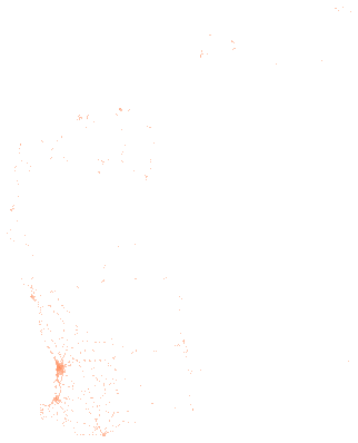
Traffic volumes at count sites, Main Roads Western Australia
liveMain Roads Western Australia's Traffic Digest, one row per traffic count site, each with its latest year of data. Each row carries the site number, road name, location description, financial year of the count, collection type, the average number of vehicles per day from Monday to Sunday, Monday to Friday and Saturday to Sunday, the percentage of heavy vehicles in each of those periods, whether it is a network performance site, the local government and the Main Roads region, and its coordinates.
Also called: Main Roads WA Traffic Digest, Traffic Digest, WA traffic volume data, Main Roads traffic counts.
- What is in each row?
- One Main Roads traffic count site, with its site number, road, location description, the financial year of its latest count, the average number of vehicles per day across the week, on weekdays and on weekends, the percentage of heavy vehicles in each, whether it is a continuously monitored network performance site, and its local government and region.
- Is this every year of counts?
- No. Each site carries only its latest year of traffic data, so the year differs between sites. A new count replaces the old one in the publisher's layer, and this site keeps each changed layer as a dated version.
- How were the counts taken?
- Main Roads monitors strategic locations continuously and samples the wider network with portable equipment over short periods. The publisher focuses on roads it manages, with many local government roads counted as well.
- Where is the publisher's file?
- This site downloads the CSV the Main Roads open data portal builds from its Traffic Digest layer.
Made for agents
Connect your AI agent
Any agent that connects to publicdata.au/mcp can find this dataset, read its 20 fields, count and filter across all 2,419 rows and diff its versions. Every answer names the version and carries Main Roads WA's attribution. No key.
Then ask it: What does Traffic volumes at count sites, Main Roads Western Australia hold, and what changed in the newest version?
claude mcp add --transport http publicdata https://publicdata.au/mcpOne command. No key, no account, no sign-up.
Settings, then Connectors, then Add custom connector, and paste https://publicdata.au/mcp.
On the web and in the desktop app.
https://publicdata.au/mcpStreamable HTTP. Cursor, VS Code or any client that connects to a remote MCP server.
Using https://publicdata.au/llms.txt, how many people died on Queensland roads in 2025, by month?For an assistant that reads the web and has no connector.
A dashboard over every row. Click to filter, add panels, share a link or embed a frame.
Query APIFilter and count from a URLaggregate?group=road_name&metric=max.mon_sun
Vehicles per day (busiest site): 185,127 Kwinana Fwy, 113,298 Graham Farmer Fwy, 101,649 Mitchell Fwy, 95,188 Tonkin Hwy.
Download it as Excel, CSV, JSON and 9 more formats
Pick a format and a version. Excel is picked first because it opens in the tools most offices have. The URL is yours to keep. A dated version never changes.
In your own tools
Use it in Excel, R, Python and more
Excel and Power BI read the CSV from its address and refresh from it. The R and Python packages take any dataset on this site by its slug, so a new dataset needs no new release. The DuckDB file attaches read-only over HTTPS, and a query reads only the blocks it touches.
The dated URL in the code never changes. https://publicdata.au/d/wa-traffic-digest/latest/ redirects to the newest version.
https://publicdata.au/d/wa-traffic-digest/latest/data.csvIn Excel choose Data, then From Web, and paste this address. Excel keeps it, so Refresh All reads the newest version. A sheet holds about a million rows; past that, load the query to the Data Model.
https://publicdata.au/d/wa-traffic-digest/latest/data.csvIn Power BI Desktop choose Get data, then Web, paste this address and choose Anonymous when asked how to sign in. A scheduled refresh reads the same address, so the report follows each new version.
library(publicdataau)
df <- pd_read("wa-traffic-digest")
pd_attribution(df)install.packages("publicdataau"). pd_read() fetches the version's Parquet file; pd_rows() and pd_aggregate() ask the query API instead, and pd_connect() attaches the DuckDB file.
import publicdata_au as pd_au
df = pd_au.read("wa-traffic-digest")
df.attrs["publicdata"]["attribution"]pip install "publicdata-au[pandas]". read() fetches the version's Parquet file; rows() and aggregate() ask the query API, and connect() attaches the DuckDB file.
INSTALL httpfs; LOAD httpfs;
ATTACH 'https://publicdata.au/d/wa-traffic-digest/v/2025-06-05/data.duckdb' AS wa_traffic_digest (READ_ONLY);
SELECT ra_name, count(*) FROM wa_traffic_digest.records GROUP BY 1 ORDER BY 2 DESC;The DuckDB file attaches read-only over HTTPS and only the blocks a query touches are read. Parquet works the same way: FROM read_parquet(url).
const res = await fetch("https://publicdata.au/api/v1/datasets/wa-traffic-digest/aggregate?group=road_name&metric=max.mon_sun");
const { rows, publicdata } = await res.json();
console.log(rows, publicdata.attribution);The query API answers a page on any site as well as Node, with no key. It returns the rows and the attribution the licence asks for.
What is in it
Column names are made snake_case and the publisher's original header is kept beside each one. Blank cells are null. Nothing is added, removed, ranked or summarised.
| Field | Type | Publisher's header | Note |
|---|---|---|---|
| x | number | X | |
| y | number | Y | |
| site_no | string | SITE_NO | |
| road_name | string | ROAD_NAME | |
| location_desc | string | LOCATION_DESC | |
| traffic_year | string | TRAFFIC_YEAR | The financial year of the site's latest count, for example 2024/25. It can be the financial year in progress. |
| collection_type | string | COLLECTION_TYPE | |
| mon_sun | number | MON_SUN | |
| mon_fri | number | MON_FRI | |
| sat_sun | number | SAT_SUN | |
| pct_heavy_mon_sun | number | PCT_HEAVY_MON_SUN | |
| pct_heavy_mon_fri | number | PCT_HEAVY_MON_FRI | |
| pct_heavy_sat_sun | number | PCT_HEAVY_SAT_SUN | |
| network_performance_site | string | NETWORK_PERFORMANCE_SITE | |
| lg_no | string | LG_NO | |
| lg_name | string | LG_NAME | |
| ra_no | string | RA_NO | |
| ra_name | string | RA_NAME | |
| objectid | integer | OBJECTID | |
| globalid | string | GlobalID |
Download this table as a data dictionary (Excel), or read it as a Frictionless Table Schema at schema.json. The key is site_no.
A sample of 10 rows
From the latest version, each main Roads region in turn, then in the publisher's order, with every field. A blank cell is shown as null.
| x | y | site_no | road_name | location_desc | traffic_year | collection_type | mon_sun | mon_fri | sat_sun | pct_heavy_mon_sun | pct_heavy_mon_fri | pct_heavy_sat_sun | network_performance_site | lg_no | lg_name | ra_no | ra_name | objectid | globalid |
|---|---|---|---|---|---|---|---|---|---|---|---|---|---|---|---|---|---|---|---|
| 120.666916 | -27.918953 | 50790 | Goldfields Hwy | North of Leinster | 2026/27 | Class | 297 | 316 | 248 | 78.5 | 77.8 | 79.4 | Yes | 608 | Leonora | 5 | Goldfields - Esperance | 7903546 | {EC224F21-DB2F-4FD5-A877-367AFAD1E270} |
| 115.7832 | -32.47575 | 50797 | Kwinana Fwy (Northbound) off to Mandjoogoordap Dr/Lymon Rd | South of Mandjoogoordap Dr | 2021/22 | Class | 787 | 831 | 662 | 13.3 | 14.7 | 10.3 | No | 212 | Mandurah (C) | 7 | Metropolitan | 7903550 | {4C675BD1-5A83-4872-8DE5-7302C43BBF7B} |
| 118.05775 | -34.8511 | 50813 | Palmdale Rd | North of South Coast Hwy | 2025/26 | Class | 152 | 194 | 70 | 44.1 | 50 | 15.7 | No | 302 | Albany (C) | 1 | Great Southern | 7903552 | {55F60A4E-3111-40C1-9196-0FC2DCF2DE8E} |
| 115.832498 | -33.303503 | 50866 | Coalfields Rd | East of South Western Hwy | 2025/26 | Class | 5701 | 6282 | 4250 | 17.2 | 18.3 | 12.9 | Yes | 211 | Harvey | 2 | South West | 7903561 | {62C4C351-57D2-47C4-8700-740ED516924A} |
| 114.68495 | -28.79377 | 50878 | Geraldton Mount Magnet Rd | West of Deepdale Rd | 2022/23 | Class | 1732 | 2002 | 1135 | 28.9 | 29.7 | 26.6 | No | 505 | Greater Geraldton (C) | 14 | Mid West-Gascoyne | 7903563 | {C00257FA-5D02-4005-AFE3-E6554363A556} |
| 117.165626 | -32.926902 | 51032 | Narrakine Rd | South of Quigley St | 2024/25 | Class | 767 | 802 | 681 | 12.3 | 13.5 | 8.8 | No | 418 | Narrogin | 8 | Wheatbelt | 7903598 | {A128054A-3E6F-4E34-A779-FFF2E9E47ED0} |
| 117.618546 | -22.627409 | 51073 | Nanutarra Rd | West of Nameless Valley Dr | 2025/26 | Class | null | null | null | null | null | null | No | 811 | Ashburton | 11 | Pilbara | 7903610 | {8EA6DB59-A234-4C33-89DE-C54C05B881B7} |
| 122.279801 | -17.717138 | 53700 | Broome Cape Leveque Rd | North of Manari Rd | 2024/25 | Class | null | null | null | null | null | null | No | 001 | Broome | 6 | Kimberley | 7903761 | {4E4B12F1-F575-4BBE-8976-E8DB543A9163} |
| 121.591752 | -31.025368 | 50791 | Goldfields Hwy | North of Kambalda | 2026/27 | Class | 2037 | 2237 | 1532 | 23.6 | 23.9 | 22.7 | Yes | 605 | Kalgoorlie - Boulder (C) | 5 | Goldfields - Esperance | 7903547 | {F34F775F-BB33-4D2C-A5C1-29F8CB2D58CD} |
| 115.825836 | -32.373835 | 50808 | Karnup Rd | East of Baldivis Rd | 2023/24 | Class | 7766 | 8278 | null | 9.5 | 9.5 | null | No | 107 | Rockingham (C) | 7 | Metropolitan | 7903551 | {F55CBF8F-BA51-45DC-95EB-10D0A1D92E33} |
The first row as JSON
As it appears in data.json.
GET https://publicdata.au/d/wa-traffic-digest/latest/data.json
{
"x": 120.666916,
"y": -27.9189529999999,
"site_no": "50790",
"road_name": "Goldfields Hwy",
"location_desc": "North of Leinster",
"traffic_year": "2026/27",
"collection_type": "Class",
"mon_sun": 297.0,
"mon_fri": 316.0,
"sat_sun": 248.0,
"pct_heavy_mon_sun": 78.5,
"pct_heavy_mon_fri": 77.8,
"pct_heavy_sat_sun": 79.4,
"network_performance_site": "Yes",
"lg_no": "608",
"lg_name": "Leonora",
"ra_no": "5",
"ra_name": "Goldfields - Esperance",
"objectid": 7903546,
"globalid": "{EC224F21-DB2F-4FD5-A877-367AFAD1E270}"
}
Query it without downloading
The query API returns only the rows you ask for, as JSON, NDJSON or CSV, from the same typed rows as the files. It needs no key. Build a query here and run it, then copy the URL or the code into your own work.
How filters work
Each filter is field=operator.value in the query string, and every filter must match. A number or date field compares as a number or date, and a text field compares as text. Values are case-sensitive except with ilike. Prefix not. to negate a filter, as not.eq.value.
| Operator | What it matches |
|---|---|
| eq.value | Equal to the value. |
| neq.value | Not equal to the value. A blank cell does not match. |
| gt.value | Greater than the value. |
| gte.value | Greater than or equal to the value. |
| lt.value | Less than the value. |
| lte.value | Less than or equal to the value. |
| like.*text* | Matches a pattern where * stands for any run of characters. Case-sensitive. |
| ilike.*text* | The same as like, ignoring case. |
| in.(a,b,c) | Equal to any value in the list. A value cannot contain a comma. |
| is.null | Blank in the source, or suppressed by the publisher. |
| Parameter | What it does |
|---|---|
| select | Fields to return, comma-separated. Every field when absent. |
| order | field.asc or field.desc, comma-separated. The publisher's row order when absent. |
| limit | Rows per page, 1 to 10,000. 100 when absent. |
| offset | Rows to skip. The next URL in each answer sets it for you. |
| group | On aggregate, fields to group by, comma-separated. |
| metric | On aggregate, count, sum.field, avg.field, min.field or max.field, comma-separated. count when absent. |
| format | json, ndjson or csv. JSON carries the provenance header, and the others carry it in response headers. |
Without a version the API answers from the newest loaded version, and that answer changes when the publisher releases again. Put versions/<date>/ before rows or aggregate for an answer that never changes. /api/v1/datasets/<slug>/versions lists the loaded versions. The 1 newest version is loaded; versions lists them.
The API allows 60 requests in 10 seconds from one address. Above that it answers 429 for 10 seconds with a Retry-After header, a RateLimit-Policy header and a JSON body that gives the limit. Every API answer carries the same RateLimit-Policy. A client should wait the Retry-After seconds, or read the files, which have no limit. openapi.json describes this dataset's query paths for client generators and agents.
https://publicdata.au/mcp is a remote MCP server over Streamable HTTP with the same tools, defined in the same place, so a tool added to the pages is added here too. It needs no key and no account. The row tools are held to the query API's limit of 60 queries in 10 seconds from one address, and each call is two queries because it also counts the matching rows. Add it to Claude Code with claude mcp add --transport http publicdata https://publicdata.au/mcp, add the URL in Claude as a custom connector, or give it to any client that connects to remote MCP servers. Each queryable dataset is also a resource at https://publicdata.au/d/<slug>/fields.json, which lists its fields with their types, the publisher's descriptions, their ranges and the values they hold, so an agent can read a dataset's shape before it writes a query.
Smaller files
The same rows split by a field, one JSON file each with a GeoJSON beside it. Each file carries the same provenance header.
By ra_name (8 files)
by/ra_name/index.json lists every file with its row count.
What changed
One version for every release the publisher has made since this site started following the dataset. The date is the day the file changed on the portal.
- 2025-06-05 2,419 rows20 fieldsutf-8-sig2e415eb3efa2
versions.json · changes.json · history.tar.zst (176 KB, every version's Parquet and manifest)
Questions
How do I download Traffic volumes at count sites as a CSV file?
Open https://publicdata.au/d/wa-traffic-digest/latest/data.csv. It redirects to the newest dated version, which is https://publicdata.au/d/wa-traffic-digest/v/2025-06-05/data.csv today. The same path serves Excel, JSON, GeoJSON, Parquet, SQLite, DuckDB, GeoPackage, GeoParquet, NDJSON, Arrow. A dated URL never changes, so use it when the file must stay the same.
Can I open Traffic volumes at count sites in Excel?
Yes. https://publicdata.au/d/wa-traffic-digest/v/2025-06-05/data.xlsx is a workbook with the 2,419 rows on a records sheet, the field list on a second sheet and the provenance on a third. The CSV also opens in Excel. https://publicdata.au/d/wa-traffic-digest/v/2025-06-05/data.csv.gz is the CSV at about a tenth of the size.
How often is Traffic volumes at count sites updated?
Main Roads WA releases it as counts are added. This site checks the portal every week and adds a dated version when the file changes.
Can I use Traffic volumes at count sites commercially?
Yes. CC BY 4.0 allows commercial use, redistribution and derived works as long as the attribution is kept. The attribution string is in this page's side column and inside every file.
Is this the official source for Traffic volumes at count sites?
No. The publisher is Main Roads Western Australia, and its page is https://catalogue.data.wa.gov.au/dataset/mrwa-traffic-digest. This site republishes the publisher's file without changing its content. The original sits beside every version as source.csv with its SHA-256, so the two can be compared.
How do I get only the rows for one ra name?
Every version has one JSON file per value of ra_name, 8 files in the current version, listed with row counts at https://publicdata.au/d/wa-traffic-digest/v/2025-06-05/by/ra_name/index.json. For example https://publicdata.au/d/wa-traffic-digest/v/2025-06-05/by/ra_name/metropolitan.json holds the 1,308 rows where ra_name is Metropolitan. A GeoJSON file sits beside each one.
What coordinate system does Traffic volumes at count sites use?
Longitude and latitude in decimal degrees as the portal's CSV download gives them. The layer itself is held in GDA94, which differs from WGS84 by under 2 metres. The GeoJSON file uses the same coordinates, which is what GeoJSON expects.
What this site did to the data. Cells were typed, headers were renamed and the encoding was made UTF-8. Rows were left alone. The publisher's file sits beside every version as source.csv so the change can be checked.