Explore Road crash locations, Queensland
Charts and tables over the 415,407 rows of the latest version, worked out in your browser from the Parquet file. Nothing you do here leaves the browser until you save a link.
Paste this where the dashboard should appear. The frame shows the attribution and links back here.
The explorer needs JavaScript and a browser from the last few years. The dataset page has every file and the query API.
Press Edit on any panel to change its chart type and drag fields into Group by, Split by and Filter. Drag a panel by its title to move or dock it, and click a bar in the first chart to filter the rest.
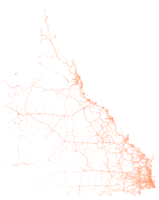
Data: Department of Transport and Main Roads, Queensland Government, Crash data from Queensland roads, sourced 24 September 2026, https://www.data.qld.gov.au/dataset/crash-data-from-queensland-roads, licensed under CC BY 4.0. Licence terms.
How it works
Change a panel
Press Edit at the top right of a panel to open its settings. Drag fields into Group by, Split by, Sort by and Filter, pick a chart type at the top, and choose sum, count or average beside each number. More fields lists everything else in the dataset. The chart types include bars, lines, areas, scatter plots, heatmaps, treemaps and sunbursts, and maps of the coordinates. Add a chart puts a new panel on the dashboard. Drag a panel's title bar to move it, or drag the line between panels to resize.
Filter every panel at once
The chart marked Click to filter the others does just that: click a bar and the other panels show only those rows. Click it again to clear. Any panel can do the same. Open the menu at the left of its title bar and turn on filtering from there.
Share or keep a dashboard
The address bar holds the whole dashboard, so copying it is enough. Save a short link to store the dashboard on this site and get a shorter address. A saved dashboard never changes; saving again after an edit makes a new link. Embed gives a frame you can paste into a web page, with the attribution inside it.
Download what you see
The export button in a panel's settings toolbar downloads the panel as CSV, JSON or Arrow, or a chart as PNG. The copy button beside it puts the same data on the clipboard. The full files are on the dataset page.
What the fields mean
The explorer names each field in words. The files and the query API use the field name beside it.
| In the explorer | Field name | Type | Note |
|---|---|---|---|
| Crash reference number | crash_ref_number | integer | The publisher's identifier for the crash. Unique within a release. |
| Severity | crash_severity | string | Fatal, Hospitalisation, Medical treatment, Minor injury or Property damage only. Property damage only crashes stop after 31 December 2010. |
| Year | crash_year | integer | |
| Month | crash_month | string | Month name. |
| Day of week | crash_day_of_week | string | |
| Hour of day | crash_hour | integer | Hour of the day, 0 to 23. |
| Nature of crash | crash_nature | string | For example Angle, Rear-end, Hit pedestrian. |
| Crash type | crash_type | string | Single Vehicle, Multi-Vehicle, Hit pedestrian or Other. |
| Longitude | crash_longitude | number | Decimal degrees, GDA2020. Blank for 598 crashes in the April 2026 release. |
| Latitude | crash_latitude | number | Decimal degrees, GDA2020. |
| Street | crash_street | string | |
| Intersecting street | crash_street_intersecting | string | Blank when the crash was not at an intersection. |
| State road | state_road_name | string | Blank on locally controlled roads. |
| Suburb | loc_suburb | string | |
| Council area | loc_local_government_area | string | |
| Postcode | loc_post_code | string | Kept as text. |
| Police division | loc_police_division | string | |
| Police district | loc_police_district | string | |
| Police region | loc_police_region | string | |
| Transport region | loc_queensland_transport_region | string | |
| Main Roads region | loc_main_roads_region | string | |
| ABS area (SA2) | loc_abs_statistical_area_2 | string | ABS SA2 name. |
| ABS area (SA3) | loc_abs_statistical_area_3 | string | ABS SA3 name. |
| ABS area (SA4) | loc_abs_statistical_area_4 | string | ABS SA4 name. |
| Remoteness | loc_abs_remoteness | string | ABS remoteness class. |
| State electorate | loc_state_electorate | string | |
| Federal electorate | loc_federal_electorate | string | |
| Road authority | crash_controlling_authority | string | State-controlled, Locally-controlled, Other or Not coded. |
| Road feature | crash_roadway_feature | string | |
| Traffic control | crash_traffic_control | string | |
| Speed limit | crash_speed_limit | string | A band such as 60 km/h or 100 - 110 km/h. Kept as text because the publisher uses bands. |
| Road surface | crash_road_surface_condition | string | |
| Weather | crash_atmospheric_condition | string | |
| Lighting | crash_lighting_condition | string | |
| Road curve | crash_road_horiz_align | string | Horizontal alignment. |
| Road slope | crash_road_vert_align | string | Vertical alignment. |
| DCA code | crash_dca_code | string | DCA (Definitions for Coding Accidents) code. Kept as text to preserve leading zeros. |
| Crash movement | crash_dca_description | string | |
| Crash movement group | crash_dca_group_description | string | |
| Approach direction | dca_key_approach_dir | string | Compass direction of the key vehicle. Blank in about 8,000 rows. |
| Deaths | count_casualty_fatality | integer | |
| People hospitalised | count_casualty_hospitalised | integer | |
| People medically treated | count_casualty_medically_treated | integer | |
| People with minor injuries | count_casualty_minor_injury | integer | |
| All casualties | count_casualty_total | integer | |
| Cars | count_unit_car | integer | Number of cars involved. |
| Motorcycles and mopeds | count_unit_motorcycle_moped | integer | |
| Trucks | count_unit_truck | integer | |
| Buses | count_unit_bus | integer | |
| Bicycles | count_unit_bicycle | integer | |
| Pedestrians | count_unit_pedestrian | integer | |
| Other road users | count_unit_other | integer | |
| SA2 code (2021) | sa2_2021_code | string | Code of the Statistical Area Level 2 (2021) the point falls in. Joined by location from abs-sa2-2021, not published by the publisher. |
| SA2 (2021) | sa2_2021_name | string | Name of the Statistical Area Level 2 (2021) the point falls in. Joined by location from abs-sa2-2021, not published by the publisher. |
| Council area code (LGA 2025) | lga_2025_code | string | Code of the Local Government Area (2025) the point falls in. Joined by location from abs-lga-2025, not published by the publisher. |
| Council area (LGA 2025) | lga_2025_name | string | Name of the Local Government Area (2025) the point falls in. Joined by location from abs-lga-2025, not published by the publisher. |
| Suburb or locality code (2021) | sal_2021_code | string | Code of the Suburb and Locality (2021) the point falls in. Joined by location from abs-suburbs-localities-2021, not published by the publisher. |
| Suburb or locality (2021) | sal_2021_name | string | Name of the Suburb and Locality (2021) the point falls in. Joined by location from abs-suburbs-localities-2021, not published by the publisher. |
| Postal area code (2021) | poa_2021_code | string | Code of the Postal Area (2021) the point falls in. Joined by location from abs-postal-areas-2021, not published by the publisher. |
| Postcode (postal area 2021) | poa_2021_name | string | Name of the Postal Area (2021) the point falls in. Joined by location from abs-postal-areas-2021, not published by the publisher. |
| State electorate code (2025) | sed_2025_code | string | Code of the State Electoral Division (2025) the point falls in. Joined by location from abs-state-electoral-divisions-2025, not published by the publisher. |
| State electorate (2025) | sed_2025_name | string | Name of the State Electoral Division (2025) the point falls in. Joined by location from abs-state-electoral-divisions-2025, not published by the publisher. |
| Federal electorate code (2025) | ced_2025_code | string | Code of the Commonwealth Electoral Division (2025) the point falls in. Joined by location from abs-federal-electoral-divisions-2025, not published by the publisher. |
| Federal electorate (2025) | ced_2025_name | string | Name of the Commonwealth Electoral Division (2025) the point falls in. Joined by location from abs-federal-electoral-divisions-2025, not published by the publisher. |
How it runs
The page downloads DuckDB and Perspective once, about 17 MB, then this version's data.parquet (24 MB). Every chart is a query DuckDB answers in the browser, so there is no rate limit and the files stay the only source. A saved dashboard over a dated version keeps showing that version's numbers. A map panel draws its background from OpenStreetMap tiles, so while one is on screen your browser asks OpenStreetMap for them and it sees your IP address. The data itself never leaves the browser.