Road crashes, New South Wales
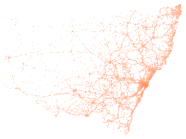
liveNSW Crash Data from Transport for NSW, one row per crash for the latest five reporting years. Each crash has its degree, year, month, day of week and two-hour band, street, town, council area and coordinates, the road and lighting conditions, the road user movement and definitions for crash type codes, the vehicles involved and the number of people killed and injured by severity.
Also called: NSW Crash Data, NSW road toll and crash statistics, Transport for NSW road crash data by crash, NSW car accident statistics.
- Which crashes are included?
- The crashes reported to NSW Police on a public road in the five reporting years of the release, in which a person was killed or injured or a vehicle was towed away. Each row is one crash, with its location, road and conditions and the number of people killed or injured.
- Why does each version cover only five years?
- Transport for NSW publishes a rolling five years each October and adds the release as a new file. This entry follows the newest file, so each version is one release. Earlier releases stay here as earlier versions.
- Can I count the road toll from this?
- The killed column counts people who died within 30 days of the crash, as the publisher reports them. Add it across the crashes of a year to get the deaths the publisher counted for that year.
Made for agents
Connect your AI agent
Any agent that connects to publicdata.au/mcp can find this dataset, read its 62 fields, count and filter across all 92,189 rows and diff its versions. Every answer names the version and carries TfNSW's attribution. No key.
Then ask it: What does Road crashes, New South Wales hold, and what changed in the newest version?
claude mcp add --transport http publicdata https://publicdata.au/mcpOne command. No key, no account, no sign-up.
Settings, then Connectors, then Add custom connector, and paste https://publicdata.au/mcp.
On the web and in the desktop app.
https://publicdata.au/mcpStreamable HTTP. Cursor, VS Code or any client that connects to a remote MCP server.
Using https://publicdata.au/llms.txt, how many people died on Queensland roads in 2025, by month?For an assistant that reads the web and has no connector.
The dashboard above, live. Click to filter, add panels, share a link or embed a frame.
Query APIFilter and count from a URLaggregate?group=speed_limit&metric=count°ree_of_crash=eq.Fatal
Crashes by speed limit where degree of crash is Fatal: 451 100 km/h, 254 50 km/h, 219 60 km/h, 211 80 km/h.
Download it as Excel, CSV, JSON and 9 more formats
Pick a format and a version. Excel is picked first because it opens in the tools most offices have. The URL is yours to keep. A dated version never changes.
In your own tools
Use it in Excel, R, Python and more
Excel and Power BI read the CSV from its address and refresh from it. The R and Python packages take any dataset on this site by its slug, so a new dataset needs no new release. The DuckDB file attaches read-only over HTTPS, and a query reads only the blocks it touches.
The dated URL in the code never changes. https://publicdata.au/d/nsw-road-crashes/latest/ redirects to the newest version.
https://publicdata.au/d/nsw-road-crashes/latest/data.csvIn Excel choose Data, then From Web, and paste this address. Excel keeps it, so Refresh All reads the newest version. A sheet holds about a million rows; past that, load the query to the Data Model.
https://publicdata.au/d/nsw-road-crashes/latest/data.csvIn Power BI Desktop choose Get data, then Web, paste this address and choose Anonymous when asked how to sign in. A scheduled refresh reads the same address, so the report follows each new version.
library(publicdataau)
df <- pd_read("nsw-road-crashes")
pd_attribution(df)install.packages("publicdataau"). pd_read() fetches the version's Parquet file; pd_rows() and pd_aggregate() ask the query API instead, and pd_connect() attaches the DuckDB file.
import publicdata_au as pd_au
df = pd_au.read("nsw-road-crashes")
df.attrs["publicdata"]["attribution"]pip install "publicdata-au[pandas]". read() fetches the version's Parquet file; rows() and aggregate() ask the query API, and connect() attaches the DuckDB file.
INSTALL httpfs; LOAD httpfs;
ATTACH 'https://publicdata.au/d/nsw-road-crashes/v/2025-10-10/data.duckdb' AS nsw_road_crashes (READ_ONLY);
SELECT year_of_crash, count(*) FROM nsw_road_crashes.records GROUP BY 1 ORDER BY 2 DESC;The DuckDB file attaches read-only over HTTPS and only the blocks a query touches are read. Parquet works the same way: FROM read_parquet(url).
const res = await fetch("https://publicdata.au/api/v1/datasets/nsw-road-crashes/aggregate?group=speed_limit&metric=count°ree_of_crash=eq.Fatal");
const { rows, publicdata } = await res.json();
console.log(rows, publicdata.attribution);The query API answers a page on any site as well as Node, with no key. It returns the rows and the attribution the licence asks for.
What is in it
Column names are made snake_case and the publisher's original header is kept beside each one. Blank cells are null. Nothing is added, removed, ranked or summarised.
| Field | Type | Publisher's header | Note |
|---|---|---|---|
| crash_id | integer | Crash ID | |
| degree_of_crash | string | Degree of crash | |
| degree_of_crash_detailed | string | Degree of crash - detailed | |
| reporting_year | integer | Reporting year | |
| year_of_crash | integer | Year of crash | |
| month_of_crash | string | Month of crash | |
| day_of_week_of_crash | string | Day of week of crash | |
| two_hour_intervals | string | Two-hour intervals | |
| street_of_crash | string | Street of crash | |
| street_type | string | Street type | |
| distance | integer | Distance | |
| direction | string | Direction | |
| identifying_feature | string | Identifying feature | |
| identifying_feature_type | string | Identifying feature type | |
| town | string | Town | |
| route_no | integer | Route no. | |
| school_zone_location | string | School zone location | |
| school_zone_active | string | School zone active | |
| type_of_location | string | Type of location | |
| latitude | number | Latitude | As published. The publisher's data manual does not state the datum. |
| longitude | number | Longitude | As published. The publisher's data manual does not state the datum. |
| lga | string | LGA | |
| urbanisation | string | Urbanisation | |
| conurbation_1 | string | Conurbation 1 | |
| alignment | string | Alignment | |
| primary_permanent_feature | string | Primary permanent feature | |
| primary_temporary_feature | string | Primary temporary feature | |
| primary_hazardous_feature | string | Primary hazardous feature | |
| street_lighting | string | Street lighting | |
| road_surface | string | Road surface | |
| surface_condition | string | Surface condition | |
| weather | string | Weather | |
| natural_lighting | string | Natural lighting | |
| signals_operation | string | Signals operation | |
| other_traffic_control | string | Other traffic control | |
| speed_limit | string | Speed limit | |
| road_classification_admin | string | Road classification (admin) | |
| rum_code | integer | RUM - code | |
| rum_description | string | RUM - description | |
| dca_code | integer | DCA - code | |
| dca_description | string | DCA - description | |
| dca_supplement | string | DCA supplement | |
| first_impact_type | string | First impact type | |
| key_tu_type | string | Key TU type | |
| other_tu_type | string | Other TU type | |
| traffic_units | integer | No. of traffic units involved | |
| killed | integer | No. killed | |
| seriously_injured | integer | No. seriously injured | |
| moderately_injured | integer | No. moderately injured | |
| minor_other_injured | integer | No. minor-other injured | |
| sa2_2021_code | string | (spine: sa2) | Code of the Statistical Area Level 2 (2021) the point falls in. Joined by location from abs-sa2-2021, not published by the publisher. |
| sa2_2021_name | string | (spine: sa2) | Name of the Statistical Area Level 2 (2021) the point falls in. Joined by location from abs-sa2-2021, not published by the publisher. |
| lga_2025_code | string | (spine: lga) | Code of the Local Government Area (2025) the point falls in. Joined by location from abs-lga-2025, not published by the publisher. |
| lga_2025_name | string | (spine: lga) | Name of the Local Government Area (2025) the point falls in. Joined by location from abs-lga-2025, not published by the publisher. |
| sal_2021_code | string | (spine: suburb) | Code of the Suburb and Locality (2021) the point falls in. Joined by location from abs-suburbs-localities-2021, not published by the publisher. |
| sal_2021_name | string | (spine: suburb) | Name of the Suburb and Locality (2021) the point falls in. Joined by location from abs-suburbs-localities-2021, not published by the publisher. |
| poa_2021_code | string | (spine: postcode) | Code of the Postal Area (2021) the point falls in. Joined by location from abs-postal-areas-2021, not published by the publisher. |
| poa_2021_name | string | (spine: postcode) | Name of the Postal Area (2021) the point falls in. Joined by location from abs-postal-areas-2021, not published by the publisher. |
| sed_2025_code | string | (spine: state_electorate) | Code of the State Electoral Division (2025) the point falls in. Joined by location from abs-state-electoral-divisions-2025, not published by the publisher. |
| sed_2025_name | string | (spine: state_electorate) | Name of the State Electoral Division (2025) the point falls in. Joined by location from abs-state-electoral-divisions-2025, not published by the publisher. |
| ced_2025_code | string | (spine: federal_electorate) | Code of the Commonwealth Electoral Division (2025) the point falls in. Joined by location from abs-federal-electoral-divisions-2025, not published by the publisher. |
| ced_2025_name | string | (spine: federal_electorate) | Name of the Commonwealth Electoral Division (2025) the point falls in. Joined by location from abs-federal-electoral-divisions-2025, not published by the publisher. |
Download this table as a data dictionary (Excel), or read it as a Frictionless Table Schema at schema.json. The key is crash_id.
A sample of 10 rows
From the latest version, newest first by reporting year, each degree of crash in turn, then in the publisher's order, with every field. A blank cell is shown as null.
| crash_id | degree_of_crash | degree_of_crash_detailed | reporting_year | year_of_crash | month_of_crash | day_of_week_of_crash | two_hour_intervals | street_of_crash | street_type | distance | direction | identifying_feature | identifying_feature_type | town | route_no | school_zone_location | school_zone_active | type_of_location | latitude | longitude | lga | urbanisation | conurbation_1 | alignment | primary_permanent_feature | primary_temporary_feature | primary_hazardous_feature | street_lighting | road_surface | surface_condition | weather | natural_lighting | signals_operation | other_traffic_control | speed_limit | road_classification_admin | rum_code | rum_description | dca_code | dca_description | dca_supplement | first_impact_type | key_tu_type | other_tu_type | traffic_units | killed | seriously_injured | moderately_injured | minor_other_injured | sa2_2021_code | sa2_2021_name | lga_2025_code | lga_2025_name | sal_2021_code | sal_2021_name | poa_2021_code | poa_2021_name | sed_2025_code | sed_2025_name | ced_2025_code | ced_2025_name |
|---|---|---|---|---|---|---|---|---|---|---|---|---|---|---|---|---|---|---|---|---|---|---|---|---|---|---|---|---|---|---|---|---|---|---|---|---|---|---|---|---|---|---|---|---|---|---|---|---|---|---|---|---|---|---|---|---|---|---|---|---|---|
| 1339151 | Fatal | Fatal | 2024 | 2024 | January | Monday | 08:00 - 09:59 | APPIN | RD | 650 | North | SOUTHERN EXPRESSWAY | OP | CATARACT | 177 | No | Not a school zone | 2-way undivided | -34.297807 | 150.90541 | Wollongong | Wollongong met. area | Syd-Newc-Woll Gtr conurbation | Curved | Embankment/cutting | null | null | Off | Sealed | Wet | Raining | Daylight | Nil | No traffic controls | 80 km/h | State | 81 | Off left/rt bnd=>obj | 803 | Off right bend into obj | Left | Vehicle - Object | Car (sedan/hatch) | null | 1 | 1 | 0 | 0 | 0 | 107021135 | Illawarra Catchment Reserve | 18450 | Wollongong | 10853 | Cataract | 2560 | 2560 | 10034 | Heathcote | 111 | Cunningham |
| 1340248 | Injury | Moderate Injury | 2024 | 2023 | December | Thursday | 12:00 - 13:59 | SYD EINFELD | DR | 15 | North | OLD SOUTH HEAD | RD | BONDI JUNCTION | 172 | No | Not a school zone | Divided road | -33.890904 | 151.253302 | Waverley | Sydney metro. area | Syd-Newc-Woll Gtr conurbation | Curved | null | null | null | Unknown / not stated | Sealed | Wet | Raining | Daylight | Nil | No traffic controls | 50 km/h | State | 30 | Rear end | 301 | Same - Rear end | null | Rear end | Car (sedan/hatch) | Car (sedan/hatch) | 2 | 0 | 0 | 1 | 0 | 118011341 | Bondi Junction - Waverly | 18050 | Waverley | 10465 | Bondi Junction | 2022 | 2022 | 10021 | Coogee | 144 | Wentworth |
| 1340242 | Non-casualty (towaway) | Non-casualty (towaway) | 2024 | 2024 | January | Monday | 12:00 - 13:59 | FOREST | RD | 300 | South | MT CARL | TRL | GOONOO FOREST | 7519 | No | Not a school zone | 2-way undivided | -31.928465 | 149.012275 | Dubbo Regional | Country non-urban | Rest of NSW - Rural | Straight | null | null | null | Unknown / not stated | Sealed | Dry | Fine | Daylight | Nil | No traffic controls | 100 km/h | Regional | 70 | Off road to left | 701 | Off carriageway to left | null | Rollover | 4 wheel drive / SUV | null | 1 | 0 | 0 | 0 | 0 | 105031103 | Dubbo Surrounds | 12390 | Dubbo | 11719 | Goonoo Forest | 2830 | 2830 | 10026 | Dubbo | 133 | Parkes |
| 1339984 | Fatal | Fatal | 2024 | 2024 | January | Wednesday | 14:00 - 15:59 | CASTLEREAGH | HWY | 3000 | North | BERIDA | RD | CURBAN | 18 | No | Not a school zone | 2-way undivided | -31.525981 | 148.556366 | Gilgandra | Country non-urban | Rest of NSW - Rural | Curved | null | null | null | Nil | Sealed | Dry | Fine | Daylight | Nil | No traffic controls | 110 km/h | State | 20 | Head on | 201 | Opp - Head on | null | Head-on | Light truck utility(from 2018) | 4 wheel drive / SUV | 2 | 1 | 0 | 2 | 1 | 105031104 | Gilgandra | 12950 | Gilgandra | 11167 | Curban | 2827 | 2827 | 10007 | Barwon | 133 | Parkes |
| 1340261 | Injury | Moderate Injury | 2024 | 2024 | January | Monday | 16:00 - 17:59 | BEAUCHAMP | RD | 10 | East | PERONNE | WAY | MATRAVILLE | 7340 | No | Not a school zone | T-junction | -33.953048 | 151.23971 | Randwick | Sydney metro. area | Syd-Newc-Woll Gtr conurbation | Straight | null | null | null | Nil | Sealed | Dry | Fine | Daylight | Nil | No traffic controls | 50 km/h | Regional | 71 | Off rd left => obj | 703 | Left off cway into object | null | Other angle | Car (sedan/hatch) | Light truck | 3 | 0 | 0 | 1 | 0 | 118021653 | Matraville - Chifley | 16550 | Randwick | 12534 | Matraville | 2036 | 2036 | 10051 | Maroubra | 122 | Kingsford Smith |
| 1340260 | Non-casualty (towaway) | Non-casualty (towaway) | 2024 | 2024 | January | Monday | 18:00 - 19:59 | THE RAMPART | MS | 0 | Right on the spot | NUMBER 7 | HN | UMINA BEACH | null | No | Not a school zone | 2-way undivided | -33.516059 | 151.300576 | Central Coast | Country urban | Syd-Newc-Woll Gtr conurbation | Curved | Steep grade | null | null | Unknown / not stated | Sealed | Dry | Overcast | Dusk | Nil | No traffic controls | 50 km/h | Local | 83 | Off rt/rt bnd=>obj | 803 | Off right bend into obj | Right | Vehicle - Object | Car (sedan/hatch) | null | 1 | 0 | 0 | 0 | 0 | 102011040 | Umina - Booker Bay - Patonga | 11650 | Central Coast (NSW) | 14025 | Umina Beach | 2257 | 2257 | 10030 | Gosford | 139 | Robertson |
| 1339986 | Fatal | Fatal | 2024 | 2024 | January | Thursday | 16:00 - 17:59 | GWYDIR | HWY | 0 | Right on the spot | GREENS | LANE | SWAN CREEK | 12 | No | Not a school zone | X-intersection | -29.668729 | 152.981533 | Clarence Valley | Country non-urban | Rest of NSW - Rural | Straight | null | null | null | Nil | Sealed | Dry | Fine | Dusk | Nil | No traffic controls | 100 km/h | State | 40 | U turn | 304 | Same - U-turn | null | Other angle | Car (sedan/hatch) | B-double (road train prior 98) | 2 | 1 | 0 | 2 | 0 | 104011081 | Grafton Surrounds | 11730 | Clarence Valley | 13721 | Swan Creek (NSW) | 2462 | 2462 | 10019 | Clarence | 132 | Page |
| 1340263 | Injury | Serious Injury | 2024 | 2024 | January | Wednesday | 16:00 - 17:59 | PACIFIC | HWY | 5300 | South | FRASER | RD | COWAN | 10 | No | Not a school zone | 2-way undivided | -33.559577 | 151.191614 | Hornsby | Sydney metro. area | Syd-Newc-Woll Gtr conurbation | Curved | null | null | null | Unknown / not stated | Sealed | Wet | Overcast | Daylight | Nil | No traffic controls | 80 km/h | State | 81 | Off left/rt bnd=>obj | 803 | Off right bend into obj | Left | Vehicle - Object | Motorcycle | null | 1 | 0 | 1 | 0 | 0 | 121021404 | Berowra - Brooklyn - Cowan | 14000 | Hornsby | 11097 | Cowan | 2081 | 2081 | 10037 | Hornsby | 104 | Berowra |
| 1340270 | Non-casualty (towaway) | Non-casualty (towaway) | 2024 | 2024 | January | Tuesday | 20:00 - 21:59 | CORRIMAL | ST | 0 | Right on the spot | NUMBER 121-125 | HN | WOLLONGONG | 581 | No | Not a school zone | 2-way undivided | -34.425289 | 150.899916 | Wollongong | Wollongong met. area | Syd-Newc-Woll Gtr conurbation | Straight | null | null | null | Unknown / not stated | Sealed | Dry | Fine | Darkness | Nil | No traffic controls | 60 km/h | State | 39 | Other same direction | 300 | Same - other | null | Other angle | 4 wheel drive / SUV | 4 wheel drive / SUV | 2 | 0 | 0 | 0 | 0 | 107041548 | Wollongong - East | 18450 | Wollongong | 14376 | Wollongong | 2500 | 2500 | 10092 | Wollongong | 111 | Cunningham |
| 1339987 | Fatal | Fatal | 2024 | 2024 | January | Friday | 16:00 - 17:59 | LAKE | RD | 20 | North | PACIFIC | ST | WOOLGOOLGA | 4007 | No | Not a school zone | 2-way undivided | -30.108237 | 153.199993 | Coffs Harbour | Country urban | Rest of NSW - Urban | Straight | null | null | null | Nil | Sealed | Wet | Overcast | Daylight | Nil | No traffic controls | 50 km/h | Regional | 73 | Off rd rght => obj | 704 | Right off cway into obj | null | Vehicle - Object | 4 wheel drive / SUV | null | 1 | 1 | 1 | 0 | 0 | 104021091 | Woolgoolga - Arrawarra | 11800 | Coffs Harbour | 14420 | Woolgoolga | 2456 | 2456 | 10020 | Coffs Harbour | 132 | Page |
The first row as JSON
As it appears in data.json.
GET https://publicdata.au/d/nsw-road-crashes/latest/data.json
{
"crash_id": 1220987,
"degree_of_crash": "Fatal",
"degree_of_crash_detailed": "Fatal",
"reporting_year": 2020,
"year_of_crash": 2020,
"month_of_crash": "January",
"day_of_week_of_crash": "Friday",
"two_hour_intervals": "22:00 - Midnight",
"street_of_crash": "HUME",
"street_type": "HWY",
"distance": 630,
"direction": "North",
"identifying_feature": "COOININEE",
"identifying_feature_type": "RD",
"town": "COOLAC",
"route_no": 2,
"school_zone_location": "No",
"school_zone_active": "Not a school zone",
"type_of_location": "Divided road",
"latitude": -34.858896,
"longitude": 148.286952,
"lga": "Cootamundra-Gundagai",
"urbanisation": "Country non-urban",
"conurbation_1": "Rest of NSW - Rural",
"alignment": "Straight",
"primary_permanent_feature": null,
"primary_temporary_feature": null,
"primary_hazardous_feature": null,
"street_lighting": "Nil",
"road_surface": "Sealed",
"surface_condition": "Dry",
"weather": "Fine",
"natural_lighting": "Darkness",
"signals_operation": "Nil",
"other_traffic_control": "No traffic controls",
"speed_limit": "110 km/h",
"road_classification_admin": "State",
"rum_code": 71,
"rum_description": "Off rd left => obj",
"dca_code": 703,
"dca_description": "Left off cway into object",
"dca_supplement": null,
"first_impact_type": "Vehicle - Object",
"key_tu_type": "Semi-trailer",
"other_tu_type": null,
"traffic_units": 1,
"killed": 1,
"seriously_injured": 0,
"moderately_injured": 0,
"minor_other_injured": 0,
"sa2_2021_code": "113031264",
"sa2_2021_name": "Gundagai",
"lga_2025_code": "12160",
"lga_2025_name": "Cootamundra-Gundagai",
"sal_2021_code": "11022",
"sal_2021_name": "Coolac",
"poa_2021_code": "2727",
"poa_2021_name": "2727",
"sed_2025_code": "10022",
"sed_2025_name": "Cootamundra",
"ced_2025_code": "138",
"ced_2025_name": "Riverina"
}
Query it without downloading
The query API returns only the rows you ask for, as JSON, NDJSON or CSV, from the same typed rows as the files. It needs no key. Build a query here and run it, then copy the URL or the code into your own work.
How filters work
Each filter is field=operator.value in the query string, and every filter must match. A number or date field compares as a number or date, and a text field compares as text. Values are case-sensitive except with ilike. Prefix not. to negate a filter, as not.eq.value.
| Operator | What it matches |
|---|---|
| eq.value | Equal to the value. |
| neq.value | Not equal to the value. A blank cell does not match. |
| gt.value | Greater than the value. |
| gte.value | Greater than or equal to the value. |
| lt.value | Less than the value. |
| lte.value | Less than or equal to the value. |
| like.*text* | Matches a pattern where * stands for any run of characters. Case-sensitive. |
| ilike.*text* | The same as like, ignoring case. |
| in.(a,b,c) | Equal to any value in the list. A value cannot contain a comma. |
| is.null | Blank in the source, or suppressed by the publisher. |
| Parameter | What it does |
|---|---|
| select | Fields to return, comma-separated. Every field when absent. |
| order | field.asc or field.desc, comma-separated. The publisher's row order when absent. |
| limit | Rows per page, 1 to 10,000. 100 when absent. |
| offset | Rows to skip. The next URL in each answer sets it for you. |
| group | On aggregate, fields to group by, comma-separated. |
| metric | On aggregate, count, sum.field, avg.field, min.field or max.field, comma-separated. count when absent. |
| format | json, ndjson or csv. JSON carries the provenance header, and the others carry it in response headers. |
Without a version the API answers from the newest loaded version, and that answer changes when the publisher releases again. Put versions/<date>/ before rows or aggregate for an answer that never changes. /api/v1/datasets/<slug>/versions lists the loaded versions. The 1 newest version is loaded; versions lists them.
The API allows 60 requests in 10 seconds from one address. Above that it answers 429 for 10 seconds with a Retry-After header, a RateLimit-Policy header and a JSON body that gives the limit. Every API answer carries the same RateLimit-Policy. A client should wait the Retry-After seconds, or read the files, which have no limit. openapi.json describes this dataset's query paths for client generators and agents.
https://publicdata.au/mcp is a remote MCP server over Streamable HTTP with the same tools, defined in the same place, so a tool added to the pages is added here too. It needs no key and no account. The row tools are held to the query API's limit of 60 queries in 10 seconds from one address, and each call is two queries because it also counts the matching rows. Add it to Claude Code with claude mcp add --transport http publicdata https://publicdata.au/mcp, add the URL in Claude as a custom connector, or give it to any client that connects to remote MCP servers. Each queryable dataset is also a resource at https://publicdata.au/d/<slug>/fields.json, which lists its fields with their types, the publisher's descriptions, their ranges and the values they hold, so an agent can read a dataset's shape before it writes a query.
Smaller files
The same rows split by a field, one JSON file each with a GeoJSON beside it. Each file carries the same provenance header.
By year_of_crash (6 files)
by/year_of_crash/index.json lists every file with its row count.
What changed
One version for every release the publisher has made since this site started following the dataset. The date is the day the file changed on the portal.
- 2025-10-10 92,189 rows62 fieldsxlsx7345189f017d
versions.json · changes.json · history.tar.zst (4.2 MB, every version's Parquet and manifest)
Questions
How do I download Road crashes as a CSV file?
Open https://publicdata.au/d/nsw-road-crashes/latest/data.csv. It redirects to the newest dated version, which is https://publicdata.au/d/nsw-road-crashes/v/2025-10-10/data.csv today. The same path serves Excel, JSON, GeoJSON, Parquet, SQLite, DuckDB, GeoPackage, GeoParquet, NDJSON, Arrow. A dated URL never changes, so use it when the file must stay the same.
Can I open Road crashes in Excel?
Yes. https://publicdata.au/d/nsw-road-crashes/v/2025-10-10/data.xlsx is a workbook with the 92,189 rows on a records sheet, the field list on a second sheet and the provenance on a third. The CSV also opens in Excel. https://publicdata.au/d/nsw-road-crashes/v/2025-10-10/data.csv.gz is the CSV at about a tenth of the size.
What years does Road crashes cover?
The current version covers 2020 to 2024. Each release from TfNSW becomes a new dated version here, and earlier versions stay online.
How often is Road crashes updated?
TfNSW releases it yearly. This site checks the portal every week and adds a dated version when the file changes.
Can I use Road crashes commercially?
Yes. CC BY 3.0 AU allows commercial use, redistribution and derived works as long as the attribution is kept. The attribution string is in this page's side column and inside every file.
Is this the official source for Road crashes?
No. The publisher is Transport for NSW, and its page is https://data.nsw.gov.au/data/dataset/2-nsw-crash-data. This site republishes the publisher's file without changing its content. The original sits beside every version as source.xlsx with its SHA-256, so the two can be compared.
How do I get only the rows for one year of crash?
Every version has one JSON file per value of year_of_crash, 6 files in the current version, listed with row counts at https://publicdata.au/d/nsw-road-crashes/v/2025-10-10/by/year_of_crash/index.json. For example https://publicdata.au/d/nsw-road-crashes/v/2025-10-10/by/year_of_crash/2024.json holds the 18,939 rows where year_of_crash is 2024. A GeoJSON file sits beside each one.
What coordinate system does Road crashes use?
Latitude and longitude in decimal degrees as published. The publisher's data manual does not state the datum; GDA94 is the NSW Government's standard and differs from GDA2020 and WGS84 by under 2 metres. The GeoJSON file uses the same coordinates, which is what GeoJSON expects.
Which SA2, council area, suburb, postcode, state electorate and federal electorate is each row of Road crashes in?
Each row with coordinates carries the SA2 (2021), Council area (LGA 2025), Suburb or locality (2021), Postcode (postal area 2021), State electorate (2025) and Federal electorate (2025) its point falls in, with the code of each. This site joins them by location against the ABS boundaries, https://publicdata.au/d/abs-sa2-2021/, https://publicdata.au/d/abs-lga-2025/, https://publicdata.au/d/abs-suburbs-localities-2021/, https://publicdata.au/d/abs-postal-areas-2021/, https://publicdata.au/d/abs-state-electoral-divisions-2025/, https://publicdata.au/d/abs-federal-electoral-divisions-2025/, and TfNSW did not publish them. The schema marks each one as joined and names the boundary version. A row without coordinates, or a point outside every area, has them blank. Place columns from Australian Statistical Geography Standard (ASGS) Edition 3 boundaries, Australian Bureau of Statistics, licensed under CC BY 4.0.
What this site did to the data. Cells were typed, headers were renamed and the encoding was made UTF-8. Rows were left alone. The publisher's file sits beside every version as source.xlsx so the change can be checked.